Skip to content

Projects

Georg Braun and Frans Hogenberg, Aerial view of Paris in the Civitates orbis terrarum (Cologne, 1572). Image credit: Rubenstein Library at Duke University, https://idn.duke.edu/ark:/87924/r4h41rn8z.

Paris of Waters

%%tb-image-alt-text%%

Paris of Waters

Focusing on the impact of water on the demographic, social, architectural, and urban development of the city of Paris through time.

Project Lead(s):

Sara Galletti

2014present

Paris of Waters is on hold while Professor Galletti is on leave.

Paris of Waters is a research project that focuses on the impact of water on the demographic, social, architectural, and urban development of the city of Paris through time. The project is concerned with water in a wide array of forms—as resource, as commodity, as means of transportation, as funnel for the city ‘s waste, and as cause of disaster and death—and with making it visible as a powerful agent of urban change. Paris of Waters challenges traditional urban history narratives—which tend to focus on design, monumentality, and the stylistic features of the built environment—by highlighting the role of infrastructure, underground works, and hydraulic management and engineering as defining elements of a city’s development and history.

Banner Image: Georg Braun and Frans Hogenberg, Aerial view of Paris in the Civitates orbis terrarum (Cologne, 1572). Image credit: Rubenstein Library at Duke University, https://idn.duke.edu/ark:/87924/r4h41rn8z

Past Collaborators

Thomas Aubert
Gaby Bloom
Ronan Bouttier
Andrew Lin
Dryden Quigley
Irene Zhou
Amanda Lazarus
Hanna Wiegers

Scholarship

Presentations

  • Galletti, Sara. “Paris of Waters.” Institut français d’archéologie orientale (IFAO). Cairo, Egypt. May 3, 2019. Galletti, Sara. “Paris of Waters.” John Hope Franklin Humanities Institute. Duke University. February 7, 2019.

Image of a vaulted ceiling showing stereotomy in the stonework. Image credit: Sara Galletti

Mapping Stereotomy

%%tb-image-alt-text%%

Mapping Stereotomy

Project Lead(s):

Sara Galletti

2017present

Mapping Stereotomy is on hold while Professor Galletti is on leave.

Mapping Stereotomy is a database dedicated to stereotomy, the art of cutting stones into particular shapes for the construction of vaulted structures. Stereotomy is best known for the variety of acrobatic masterpieces produced in early modern France and Spain. Yet the art is neither early modern nor European; it has been practiced over a wide temporal span, from Hellenistic Greece to contemporary Apulia, and across a broad geographical area, centered on the Mediterranean Basin but reaching far beyond—from Cairo to Gloucester and from Yerevan to Braga. Mapping Stereotomy consolidates and visualizes information on stereotomic vaults from antiquity through early modernity, with the aim of furthering and broadening research in the fields of construction techniques and Mediterranean studies.

Banner Image: Image of a vaulted ceiling showing stereotomy in the stonework. Image Credit: Sara Galletti

Past Collaborators

Margarete Calmar
Kristin Love Huffman
Angela Tawfik
Hannah Wolfe

Scholarship

Articles

  • Galletti, Sara. “Philibert de L’Orme’s theory of stereotomy in the Premier tome de l’architecture.” Thinking3D. April 16, 2018. Galletti, Sara. “Stereotomy and the Mediterranean: Notes Toward an Architectural History.” Mediterranea. International Journal on the Transfer of Knowledge 2 (2016): 73-120. doi:10.21071/mijtk.v0i2.6716.

Presentations

  • Galletti, Sara. “Mapping Stereotomy: Vaulting in the Ancient and Medieval Mediterranean.” Paper presented at Digital Matters in Medieval and Renaissance Studies, Duke University, Durham, NC, April 6-7, 2018.
  • Galletti, Sara. “Stereotomy: A Mediterranean History.” Society of Architectural Historians, Annual International Conference. April 18, 2018 – April 22, 2018.
  • Galletti, Sara. “Stereotomy: a Mediterranean History.” Vanderbilt University. October 29, 2018.

A section of Jacopo De' Barbari's View of Venice showing the mythic god Mercury. Cropped from a high resolution digital image of the print housed in the Minneapolis Institute of Art's permanent collection.

A Portrait of Venice

%%tb-image-alt-text%%

A Portrait of Venice

Project Lead(s):

Kristin Love Huffman

2015present

This research project centers on Jacopo de’ Barbari and Anton Kolb’s View of Venice, a multi-sheet woodcut published in 1500 that exemplifies a high-point of printmaking innovation in Venice. Early scholarly outputs include an exhibition featured at Duke University’s Nasher Museum of Art in 2017 (September-December). In spring of that year, the Civic Museums of Venice and Visualizing Venice/Visualizing Cities embarked on a study of the six original wooden blocks housed in the Correr Museum (Museo Correr) at Piazza San Marco, Venice. Ongoing initiatives comprise an installation of digital stories at the Correr alongside the original wooden blocks and one of twelve surviving first-state prints. In addition, an edited volume, A Portrait of Venice: Jacopo de’ Barbari’s View (forthcoming from Duke University Press), with essays by over 20 scholars, recounts various thematic narratives of early modern Venice, using the print as a point of departure. And finally, the investigative study is resulting in a scholarly analysis of the making of the View, realized by the comparative study of the woodcuts, wooden blocks, and digitally captured imagery. To access the high-resolution image, please see this link (a collaboration between the Digital Art History and Visual Culture Research Lab, formerly the Wired! Lab, and Duke Libraries).

For further information on the View of Venice, digital approaches as part of a long tradition of art historical methodologies, and the conception of the exhibition, see “Jacopo de’ Barbari’s View of Venice (1500): “Image Vehicles” and “Pathways of Culture” Past and Present.”

Current Collaborators

Ludovica Galeazzo
Hannah L. Jacobs

Past Collaborators

Lizzet Clifton
Nevio Danelon
Iara Dundas
Sydney Harrington
Annie Haueter
Julia Huang
Hannah L. Jacobs
Andrew Lin
Laura Moure Cecchini
Elisabeth Narkin
Charlie Niebanck
Elizabeth Speed
Edward Triplett
Mary Kate Weggeland

Scholarship

Books & Book Chapters

  • Huffman, Kristin Love, A Portrait of Venice. Jacopo de’ Barbari’s View of 1500. Durham, NC: Duke University Press, 2021.

Exhibitions

  • Huffman, Kristin Love. A Portrait of Venice: Jacopo de’ Barbari’s View of 1500. Nasher Museum of Art, September 7, 2017-December 31, 2017.

Articles

  • Huffman, Kristin Love. “Jacopo De’ Barbari’s View of Venice (1500) ‘Image Vehicles’ and ‘Pathways of Culture’ Past and Present.” Mediterranea. International Journal on the Transfer of Knowledge 4 (2019): 165-214. doi:10.21071/mijtk.v4i0.11530.

Presentations

  • Huffman, Kristin Love. “500-Year-Old Wooden Blocks, Light Laser Scans & Photogrammetry.” Paper presented at Digital Matters in Medieval and Renaissance Studies, Duke University, Durham, NC, April 6-7, 2018.
  • Huffman, Kristin Love. “A ‘Virtually’ Digital Exhibition.” University of Padua, Italy, 2017.
  • Huffman, Kristin Love. “A Portrait of a City: Jacopo de’ Barbari’s Venice.” Florida State University, 2019.
  • Huffman, Kristin Love. “A Portrait of Venice.” University of Kansas, 2017.
  • Huffman, Kristin Love. “A View from Above: Jacopo de’ Barbari’s Venice.” Ballroom of the Correr Museum, 2018.
  • Huffman, Kristin Love. “Jacopo de’ Barbari’s View of Venice.” University of Washington at St. Louis, 2017. Huffman, Kristin Love. “The View of Venice and the Making of Knowledge.” University of Padova, 2018.
  • Huffman, Kristin Love. “The View of Venice.” School of Engineering, Duke University, 2017.
  • Huffman, Kristin Love. “The Wooden Blocks of Jacopo de’ Barbari’s Celebrated View of Venice.” Renaissance Society of America, New Orleans, March 2018.
  • Huffman, Kristin Love, and Mark DeLong. “500-Year-Old Wooden Blocks, Light Laser Scans & Photogrammetry.” Paper presented at Digital Matters in Medieval and Renaissance Studies, Duke University, Durham, NC, April 6-7, 2018.

Funding & Sponsorship

  • National Endowment of the Humanities-Mellon Fellowship (2017-2018)
  • Duke Digital Initiative Grant (2017)
  • Gladys Krieble Delmas Institutional Foundation Research Grant (2016-2017)

A portion of the Alife Arch digitally annotated to show a human figure's shape in green. Image Credit: Julia Liu

Alife Arch App

%%tb-image-alt-text%%

Alife Arch App

2016present

This wonderful arch, housed at the Nasher Museum of Art, consists of intertwined men and animals combined in a frightening vision of suffering in Hell or Purgatory. The arch is from the Cathedral of Alife, an ancient Roman city near Naples, Italy, and is a remarkable example of Italian Romanesque sculpture. The analysis of the marble of the individual pieces indicates that they were carved from Roman materials originally from quarries in Italy, Turkey, and the Greek islands. Fragments of ancient sculpture (spolia) can be seen on the reverse side of the medieval carving.

A team of Duke students is developing an interactive visualization to engage museum visitors with the history and meaning of this remarkable work of art.

The current project draws on previous work completed by Angelina Liu (MA in Computational Media ’19), students in the spring 2016 course ARTHIST 551SL Advanced Digital Art History, and a prior student project by Joseph Williams (PhD in Art History) and Kiki Fox (Trinity ’12). Williams and Fox first captured the arch using photogrammetry technologies, a process that has been repeated as technologies have advanced and as an opportunity to teach photogrammetry techniques. Williams and Fox also researched the ancient marble trade and comparative fragments to better understand how they may have been originally used in ancient architecture before being repurposed.

Current Collaborators

Caroline Bruzelius

Past Collaborators

Jessica Chen
Anna Cunningham
Marina Frattaroli
Lucas Giles
Hannah L. Jacobs
Adair Jones
Lucian Li
Angelina Liu
Gabriella Salvatore
Edward Triplett

Water and Food in Venice

%%tb-image-alt-text%%

Water and Food in Venice

Stories of the Lagoon and the City

Project Lead(s): Donatella Calabi, Gabriella Belli

Spring 2015Summer 2015

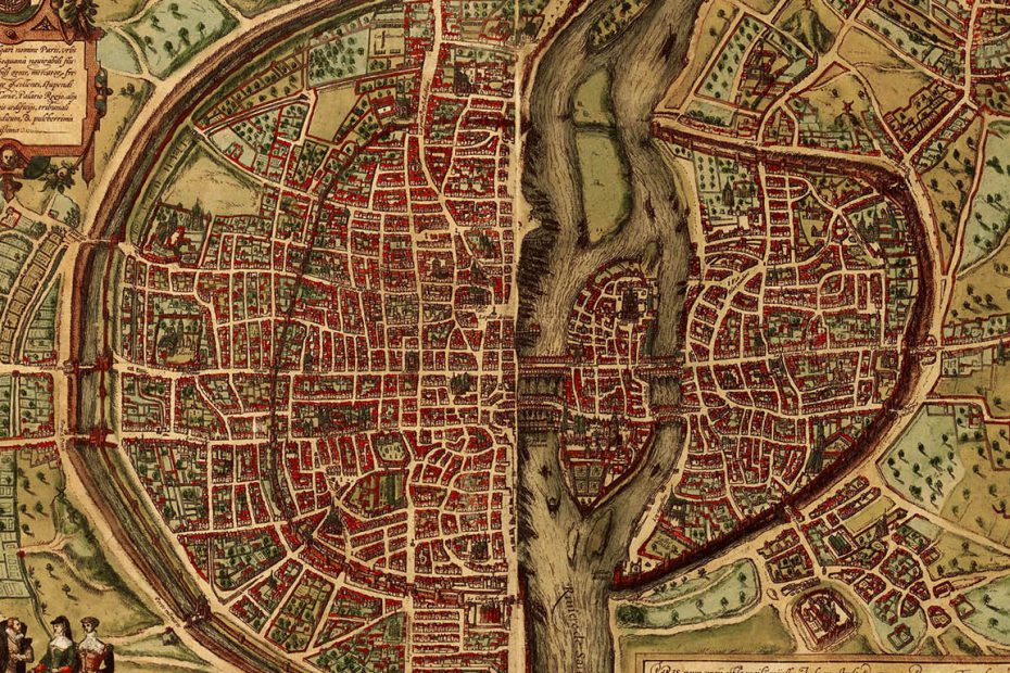
Venice was created as a series of transitions from mainland to lagoon, from lagoon to the Mediterranean, and eventually to a network of ports and islands that became part of an empire of commerce. The original settlement, built on low tidal islands, was created in a precarious balance between the land and water, the community permeated by canals in a continuous, complex and skillfully leveraged relationship. The contrast between “natural” and “artificial” has always been a distinctive feature of the city, an emblem of Venetians’ inventiveness and tenacity as well as of nature’s destructive and transformative force.

The lagoon therefore conditions the city: they exist in a contrapuntal dialogue, the voice of each essential to the whole. This profound connectedness between Venice and the lagoon is expressed in historic maps, which show the city in the center, defended by a cordon of beaches that separate and protect it from the open sea: a lagoon full of islands of fields, churches and clock towers. The co-existence of fishing, hunting, and agriculture (the cultivation of all kinds of fruits and vegetables, vineyards and herbs) in the lagoon habitat both permitted and promoted Venice’s development. Religious communities were vital nodes in a system of food production and trade: starting in the earliest centuries after the founding of Venice, a series of island monasteries supported a stable galaxy of farms, saltworks, mills, and fish producers.

Historic images of Venice show another unique feature of Venice: a city without enclosing walls. The lagoon, with its strategically located forts, religious establishments, hospitals and quarantine stations, was the real “wall” of the city. Venice redesigned the natural landscape, and sometimes with majestic architecture, to protect itself from human enemies and disease.

Our exhibition, Water and Food in Venice. Stories of the Lagoon and the City, opened September 26, 2015 at the Ducal Palace, is the result of a long-term research initiative developed by an international team of young historians of art, architecture and cities. The group includes experts in mapping, modeling and multimedia from Iuav (Venice), University of Padua, and Duke University via the Visualizing Venice/Visualizing Cities collaborative. Water and Food in Venice is the first public-facing presentation of the multifaceted collaboration that began in 2010 as “Visualizing Venice” the joint inspiration of Caroline Bruzelius (Duke University) and Donatella Calabi (University IUAV of Venice).

A key feature of the exhibition is to model how the support systems for the Republic of Venice addressed questions that are critical on a global scale to us today: supplying densely-inhabited communities with fresh food and water. The exhibition offers the opportunity to consider historical models for large-scale environmental management in a setting unique in its challenges and diversity. The exhibition forms part of larger initiatives connected with the 2015 International Exposition in Milan, “Feeding the Planet.”

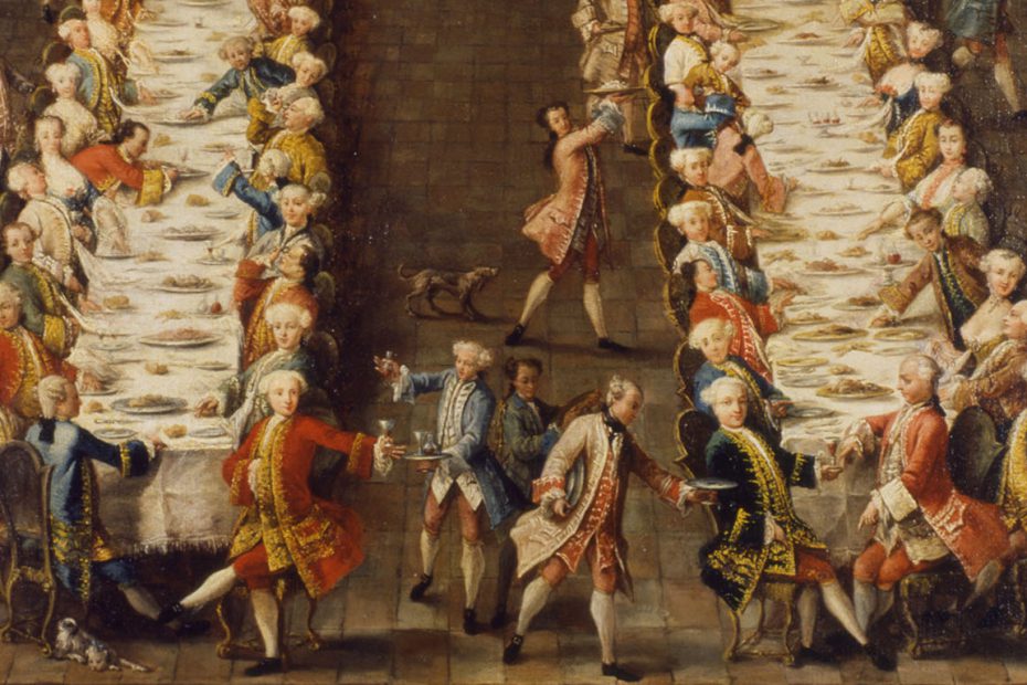
Banner Image: Detail of Pietro Longhi’s Convito in Ca’ Nani.

Past Collaborators

Kristin Love Huffman (Curator of Banquets, Parades, and Festivals)

Image showing photogrammetric phases of creating a digital model. The object is a 15th-century Incan pacha in the Nasher Museum of Art’s permanent collection. Image Credit: Edward Triplett

Art of the Americas Interactive

  • Objects
%%tb-image-alt-text%%

Art of the Americas Interactive

2019present

This project is a partnership with the Nasher Museum to re-imagine the exhibition of the museum’s collection of ancient American Art, one of the best university art museum collections of work by Maya, Aztec, and Inca cultures. For over 25 years, this collection has sat largely untouched in museum storage. With a new specialist on staff, the museum has begun studying and preparing this collection for display.

One exhibition, Cultures of Sea, opened February 1, 2020, and delves into the relationship of ancient Americans to the ocean, featuring ceramics, textiles, and bone and wood carvings of crabs, lobsters, sting rays, sea birds, shells, and other sea creatures. A longer term goal of the project is to mount a new reinstallation of the Art of the Americas gallery to feature artwork from South America. A crucial component of both of these exhibitions is the production of digital 3D models of pieces in the collection for both research and teaching purposes.

We aim to use this technology and other digital means to move beyond the realm of vision to capture the full sensory experience of the ancient Americas, including the sounds, bodily sensations, and textures generated by artworks. The creation of a model of a Chancay ceramic vessel, for example, leads to critical discoveries about artistic process and original function: How does the study of its texture reveal the technique of ancient Peruvian ceramic artists? How does a replica allow us to study its performative use and the way it held liquid and emitted sound when poured?

With COVID-19 preventing in-person access to the Cultures of the Sea exhibition, an online, interactive 360 immersive version was created in summer 2020.

Image Credit: Views of a 3D scan of an Art of the Americas object from the Nasher Museum of Art collection. Inca, Pacha with Ears of Corn, 1438–1532. Terracotta with slip, 4 1/4 x 4 1/4 inches (10.8 x 10.8 cm). The Paul A. and Virginia Clifford Collection, 1973.1.408.

Current Collaborators

Lilly Clark
Luke Evans
Nathan Ostrowski
Andrew Witte
Aston Young

Past Collaborators

Clara Pinchbeck

Prototype for an augmented reality experience at Duke. Image credit: Victoria Szabo

Augmenting Urban Experiences

%%tb-image-alt-text%%

Augmenting Urban Experiences

Project Lead(s):

Victoria Szabo

2014present

This project focuses on the conceptual framework and processes of digital city-making itself, drawing upon Technology Studies and Media Theory as well as historical documents, monuments, architecture, and other cultural artifacts. Researchers in this team are focused on the development of digital and mixed-reality experiences as tools for discovery and research presentation and exhibition. We focus on annotated digital maps, 3D modeling, augmented reality overlays, audio and video supplements, procedural narrations, data visualizations, and network flow diagrams in order to understand both the past of a city and its presence or effects in contemporary experiences of it. In close connection with partners in the international Visualizing Cities consortium, and with collaborative projects running in Durham, NC; Venice; Bremen; and Providence, RI, we are developing a mobile app framework for on-site exploratory and interactive experiences. The project goals are both to create multimodal research products that take advantage of the affordances of both analog and digital media forms, and to develop guidelines for an emerging genre for research presentation and transformative, affective experiences in real time and space. This approach includes abstracting principles from collaborative projects like the Digital Durham website and interactive exhibitions on-site in the city; the NC Jukebox exploration of NC folk music in the context of early 20th century North Carolina; the Visualizing Lovecraft project, which focuses on spatialized and exploratory forms of literary criticism and interpretation; Ghett/App, which focuses on the historical and architectural experience of the Venetian Ghetto; and augmented experiences in Mapping Occupied Krakow.

Model of a medieval Portuguese fortress with its historical documentation in the background. Image Credit: Book of Fotresses project team.

Book of Fortresses

%%tb-image-alt-text%%

Book of Fortresses

Project Lead(s):

Edward Triplett

2017present

The aim of the Book of Fortresses project is to spatially reconstruct an exceptional architectural source from early modern Portugal called the Livro das Fortalezas (Book of Fortresses). The book contains 120 perspective drawings and architectural plans of more than 55 fortresses and fortified towns along the border between Portugal and Spain. It also contains a brief but clear itinerary followed by the book ‘s author (a Portuguese Squire named Duarte de Armas) when he traveled to each site in 1509. The digital project takes a multi-scale approach to the book. At the architectural scale, the project team is constructing parametric 3D models of the fortifications according to Duarte de Armas’ measured plans and perspective drawings in order to better understand his visualizations. 3D “billboards” of d’Armas’ perspective drawings are also oriented to the landscape within a 3D GIS and in the Unity game engine. Finally, at the national/peninsula scale, Duarte de Armas’ itinerary is plotted with viewshed analyses from each site in order to analyze whether it is appropriate to refer to the string of fortresses as a “chain” or “borderline.” In January 2020, the Office of Digital Humanities at the National Endowment of the Humanities (NEH) awarded Ed Triplett and Phil Stern (Duke, Department of History) a level II grant to develop the methodologies implemented by the Book of Fortresses project into an applicable workflow for visualizing non-cartesian maps and views using a combination of GIS, CAD, and game engine software.

Current Collaborators

Daniel Castro
Brittany Forniotis
Hillman Han
Audrey Magnusen

Past Collaborators

Cyan DeVeaux (Trinity ’20)
Rory Dierman
Cameron Esses
Stone Mathers (Trinity ’20)

Related Projects

Sandcastle

Scholarship

Books & Book Chapters

  • Triplett, Edward. “Drawing Borders with Castles and Maps —Making Sense of the 16th Century Livro das Fortalezas.” in Genius Loci: Early Modern Architectural Practices and the Construction of Place. Amsterdam: Amsterdam University Press, 2020.

Presentations

  • DeVeaux, Cyan, Edward Triplett, and David Zielinski. “Immersive Chorography: Experiencing the Book of Fortresses through Virtual Reality.” Poster presented at the Research Computing Symposium, Duke University, Durham, NC, February 5, 2020.
  • Triplett, Edward. “The Book of Fortresses: An Early Modern Visualisation of a Historical Buffer-Zone.” Paper presented at Digital Matters in Medieval and Renaissance Studies, Duke University, Durham, NC, April 6-7, 2018.
  • Triplett, Edward. “Borders and Panoramas in Early Modern Portugal: Integrating Architectural and National-Scale Spatial Analyses with 3D GIS.” in “DH in 3D: Multidimensional Research and Education in the Digital Humanities.” American Historical Association Annual Meeting, Chicago, IL, January 2019.
  • Triplett, Edward. “Drawing Borders with Castles and Maps—Making Sense of the 16th Century Livro das Fortalezas.” Paper presented at The Spaces of Early Modern Architectural Production, Max-Planck-Institute für Wissenschaftsgeschichte, Berlin, Germany, May 17, 2018.
  • Triplett, Edward. “Historical Mapping in Three Dimensions: Obstacles and Opportunities” in”Geographical History: From Maps as Documents to Maps as Method.” Panel presented and co-organized with Susan Gagliardi at the American Association of Geographers conference, Boston, MA, April 2017.
  • Triplett, Edward. “Maps and Views, Plans and Landscapes: The Capabilities of 3D GIS in Liberal Arts Teaching and Research.” Keynote Paper for “Fostering Humanistic Tools for Digital Mapping” ACM Faculty Career Advancement Program at St. Olaf College, Northfield, MN, July 2019.

Panorama of the Duke Chapel. Image credit: Luca Vascon

Building Duke

%%tb-image-alt-text%%

Building Duke

The Architectural History of Duke Campus from 1924 to the Present (2018-2019)

Project Lead(s):

Sara Galletti,

Kristin Love Huffman,

Hannah L. Jacobs,

Augustus Wendell

2018present

Building Duke is on hold while Professor Galletti is on leave.

Building Duke is a three-year initiative that will be implemented in three phases: data collection and organization (first year); data analysis and interpretation (second year); data output (third year). It will explore the conception, design, and construction of the Duke University campus as well as its changes and expansions. The project has been supported by successive Bass Connections Project Grants. Principal aims are to offer an historical narrative of the physical environment that the Duke community inhabits and to explore the desires and visions that have materialized in the making of the campus. This project is especially relevant at a cultural and political moment when physical space and its historical connotations are at the center of a heated public debate. The three-year initiative will culminate in a relational database of textual and visual archival material on the architectural history of Duke campus; an interactive digital 3D model of campus developments since the 1920s; a series of multimedia thematic narratives on the history of the campus; and a series of augmented reality tours.

Current Collaborators

Elizabeth Baltes
John H. Edinger
Brittany Forniotis
Valerie Gillispie
Dana Hogan
Amanda Lazarus
Kayla Marr
Amy McDonald
Mark J. V. Olson
Arial Strode
Victoria Szabo
John Taormina
Edward Triplett
Luca Vascon
Daniella Welton

Past Collaborators

Nathan Bullock (PhD in Art History ’19)
Jacqui Geerdes
Rayhan Jhanji
Ashley Kwon
Manuela Maggipinto
Priya Parkash
Clara Pinchbeck (MA in Digital Art History ’20)
Dryden Quigley
Sarah Riazati (MFA in Experimental Documentary Arts ’19)
Kerry Rork
Abby Shlesinger
Holly Stam
Cassandra Stecker
Valerie Tsao
Maggie Wang

Image of an Athenian Cemetery.

Death, burial and commemoration in Athens

%%tb-image-alt-text%%

Death, burial and commemoration in Athens

From antiquity to the Late 19th century

Project Lead(s):

Sheila Dillon

20132014

This research project is a multi-faceted, diachronic study of the commemoration of the dead in Athens, which explores the shifting locations of burial, the findspots of sculpted tombstones, and the changing ways in which graves were marked from antiquity to the late 19th century CE. The visualization of change over time through mapping and 3D modeling and the construction of an interactive database are major aims of this project. The first phase will focus on the Kerameikos, the principle burial ground of ancient Athens, and the First Cemetery of Athens, established in the early years of the modern Greek state.

Related Projects

Digital Athens