Hear from Dictionary co-PIs Lee Sorensen and Hannah Jacobs about the history of the project.
The Dictionary of Art Historians started as a long-standing private research tool which joined the Wired! Lab in 2017. As an open-source public database, it holds the largest public presence of the Wired! projects. The founding purpose was to trace methodologies of past art historians through their intellectual biographies. After joining the Wired! Lab, the Dictionary was reconfigured to a new CMS, allowing it to answer new questions about race, gender, national identity within art history and to visualize these relationships by presenting the data in unique ways.
Almost immediately after joining the lab, undergraduates entered the project, initially by researching and writing new entries. Soon however, the questions they encountered led to self-directed research projects in Art History, most notably data mining women art historians, a traditionally overlooked but significant component of early twentieth-century art writing. Another project has involved tracing art historians fleeing Nazi Germany, the export of their German-style method, and their subsequent diaspora into the United States and England.
At Wired!’s ten-year mark, the Dictionary has engaged more students than any other Wired! program, cross-training students in the Humanities and STEM-concentrations with each other’s area skills, including coding, archival research, visualization, and the history of the Humanities. Student researchers come from a wide variety of majors including Public Policy, Pre-Medicine, Economics, and History. Every entry in the Dictionary bears the student’s name permanently on the site providing an internet presence documenting their work. Since its inception, the Dictionary has engaged nearly thirty Duke students and become a principal tool in art historiographical research, linked from over eighty research institutions and cited in numerous doctoral thesis.
Current Collaborators
Alana Hyman
Eleanor Ross
Emilie Menzel
Kerry Rork
Paul Kamer
Sorensen, Lee, and Hannah L. Jacobs. “Updates from the Dictionary of Art Historians.” Presentation at the Art Historians’ Archives Workshop, Getty Research Institute, January 28, 2019.
The Digital Athens project began in the fall of 2014. The initial aim of this project was to produce a comprehensive digital map in ArcGIS of the archaeological remains of ancient Athens uncovered both in systematic and rescue excavations. The project began as a collaborative endeavor, and involved undergraduate and graduate students at Duke as well as colleagues based in Athens at the American College of Greece (Deree) and the American School of Classical Studies at Athens (ASCSA). The Duke team focused on digitizing and geo-referencing excavation plans and historical maps, and plotting the locations of burials, wells, workshops, public buildings, and sacred structures. The visualization of how the city changed over time was a major aim of this project. In addition to the research cluster in the Wired! Lab, the Digital Athens project has also involved two iterations of the course, The Art and Archaeology of Ancient Athens, which was team-taught virtually between Duke and Deree in both 2014 and 2017 and included a spring break trip for the Duke students to Athens.
The next phase of the project, which began in the summer of 2020, is focused on the history of excavations in the Athenian Agora, which started in the 1930s under the auspices of the ASCSA. In this phase, we aim to visualize the houses, businesses, churches, and families that comprised the early 20th-century neighborhood known as Vrysaki, which occupied the site of the Athenian Agora and was destroyed to make way for the excavations. The aim is to build a content-rich website, with historical photographs and 3D models of the now-absent buildings, that will tell the history of this once vibrant area of the city that was one of the most densely populated neighborhoods of Athens.
Hear Timothy Shea (PhD in Art History ’18) talk about his experience with the Wired! Lab and the Digital Athens project.
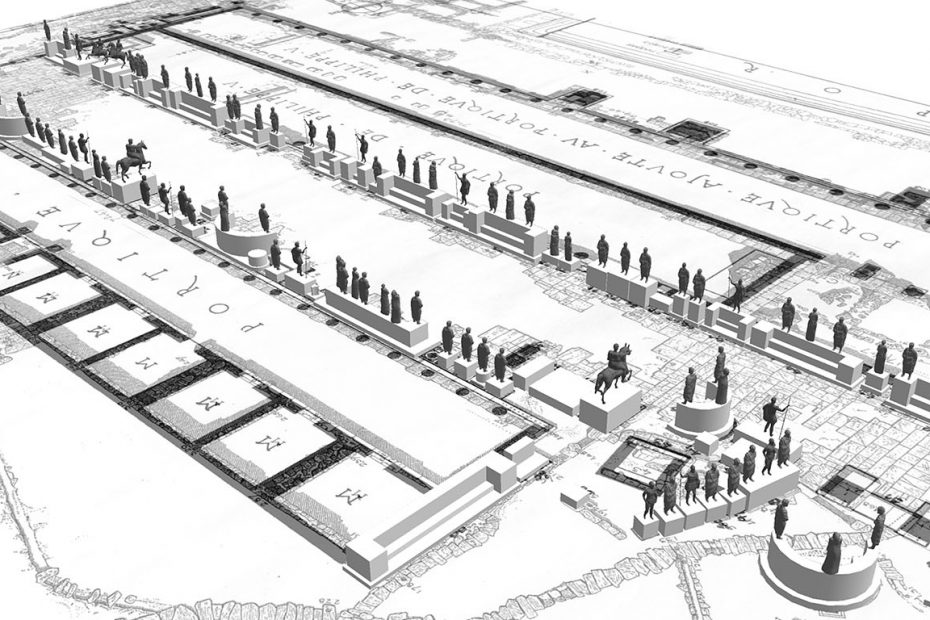
Banner Image: Screen shot of the SketchUp model of portrait statues along the Dromos on Delos, ca. 100 BC. Model developed by Elizabeth Baltes and Sheila Dillon
Current Collaborators
Dr. Leda Costaki, Research Archivist, American School of Classical Studies at Athens
Bruce Hartzler, IT Specialist, Agora Excavations, American School of Classical Studies at Athens
Past Collaborators
Julian Salazar, Trinity ‘15
Alexandra Smith, Trinity ‘15
Alina Taalman, MFA/EDA ‘15
Casey Tissue, Trinity ‘16
Anna Vivian, Trinity ‘16
Baltes, Elizabeth P. “Itinerant Statues? The Portrait Landscape of the Athenian Agora.” In Greek Art In Context: Archaeological and Art Historical Perspective, edited by Diana Rodríguez Perez. New York: Routledge, 2017.
Presentations
Shea, Timothy D. “Contextualizing Classical Attic Tombstones: Using GIS to Reconstruct the Ancient Cemeteries of Athens.” Graduate Student Symposium, Department of Art, Art History, and Visual Studies, Duke University. Spring 2015.
Shea, Timothy D. “Digitizing Athens: Reconstructing the Urban Topography of Athens with GIS.” SECAC (formerly Southeastern College Art Conference) Annual Meeting, Pittsburgh. Refereed. Fall 2015.
Shea, Timothy D. “Mapping Ancient Athens in a Classroom: The Digital Athens Project at Duke University.” Mapping the Past: GIS Approaches to Ancient History, Ancient World Mapping Center, University of Carolina at Chapel Hill. Refereed. Spring 2016.
Shea, Timothy D. “Mapping Immigrant Communities through Their Tombstones in Classical Athens,” Department of Classics, Dartmouth College. October 2018.
Shea, Timothy D. “The Dead among the Living: Mapping Classical Attic Tombstones.” Archaeological Institute of America Annual Meeting 2016, San Francisco. January 2016
Shea, Timothy D. “The Digital Athens Project.” Digital Humanities Sandbox Chat, Franklin Humanities Institute, Duke University. Spring 2015.
Shea, Timothy D.”Digital Athens: Archaeology meets ArcGIS.” Conversations in the Digital Humanities Lecture Series, Perkins Library, Duke University. Fall 2015.
The Digital Durham archive brings together numerous documents, maps, images, census data, and other primary source materials in a digital form accessible and searchable on the web. This project seeks to activate the archive as a teaching tool and public history resource through the use of annotated maps, multimedia-illustrated essays, and augmented reality tours of the city itself. Students in various Digital Durham related classes over the years have contributed not only to the archive itself, but also to deeper dives into specific research questions about Durham history as localized phenomena of spatial and temporal significance as they relate to race, religion, culture, and economic status. This work is reflected on the site and in online projects. In addition, some of these essays are being translated to augmented reality experiences accessible via mobile device from specific GPS points in the city, an approach that highlights the importance of their physical materiality and experience of the space itself as we reflect upon historical change over time. Through partnerships with local history institutions, libraries, and schools, we are also exploring collaborative approaches to public history-making in various city neighborhoods as well, including the Walltown area adjacent to Duke’s East Campus. This project was part of Bass Connections. Current expansions include georectified historic maps of the city, TEI-encoded letters from the Rubenstein Library’s Charles N. Hunter collection, including the Richard Wright letters, and the development of an interactive digital scrapbook from Hunter’s clippings from the late 19th- and early 20th-century African American press.
Banner Image: Durham, North Carolina: Annexation Map from the Durham (N.C.). Department of Public Works, Publisher. Source: Digital Durham
Digital Public Buildings in North Carolina focuses on the public architecture of North Carolina, from the early Republic to today. Under a general interest in the political history of architecture, we research major building types (prisons, schools, museums, city halls, etc.) and develop digital maps to visualize the results. The point of the multiyear project will be to produce a dynamic and interactive digital map that allows art historians to query general patterns in publicly sponsored building activity across the state. In addition, specific research into key monumental structures will be highlighted through digital storytelling and other means.
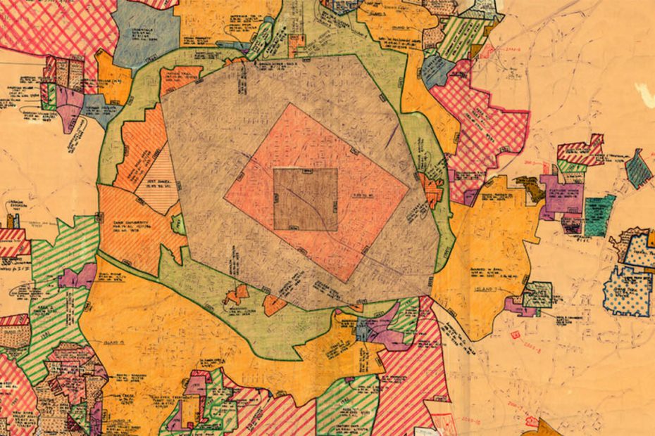
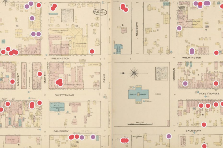
Banner Image: A Sanborn map annotated to show the locations where Black people worked and lived in early-twentieth-century Raleigh. Map Credit: Paloma Rodney
You can access the Digital County Courthouses in North Carolina project below, and access it directly here.
Current Collaborators
Savannah Fitzpatrick
Oliver Hess
Ruth Player
Malynda Wollert
Past Collaborators
Paloma Rodney
Funding & Sponsorship
Trinity Research Enhancement Awards (2018-2019, 2022-2023)
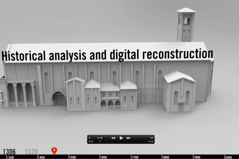
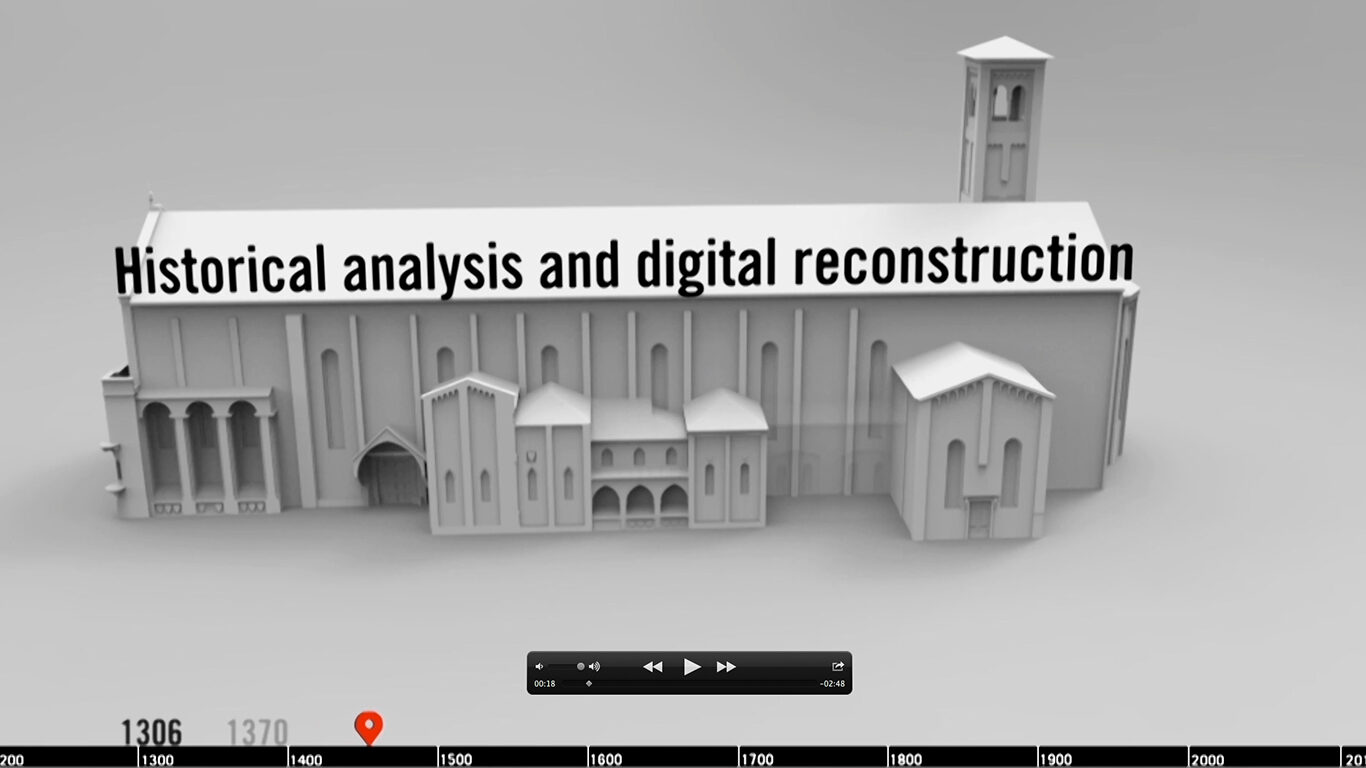
The Church of the Eremitani in Padua was almost entirely destroyed in the Second World War. Prior to this terrible event, the church was an important center for the spiritual life of Padua, and contained many important works of art, including a chapel decorated with monumental frescoes by Mantegna. Although the building is reconstructed, the restorers themselves made a series of strategic decisions about what and how to repair the monument. Only isolated fragments of Mantegna ‘s majestic cycle survive, applied to large-scale photographic images of the frescoes prior to their demolition.
This project consists of a complete laser scan and a reconstruction of the church in relation to successive phases of modifications and additions since the early fourteenth century. The project engages with the long history of the Eremitani church as the aggregate of human interventions that added, removed, changed and reconceptualized different parts of the monument over time.
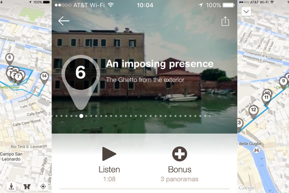
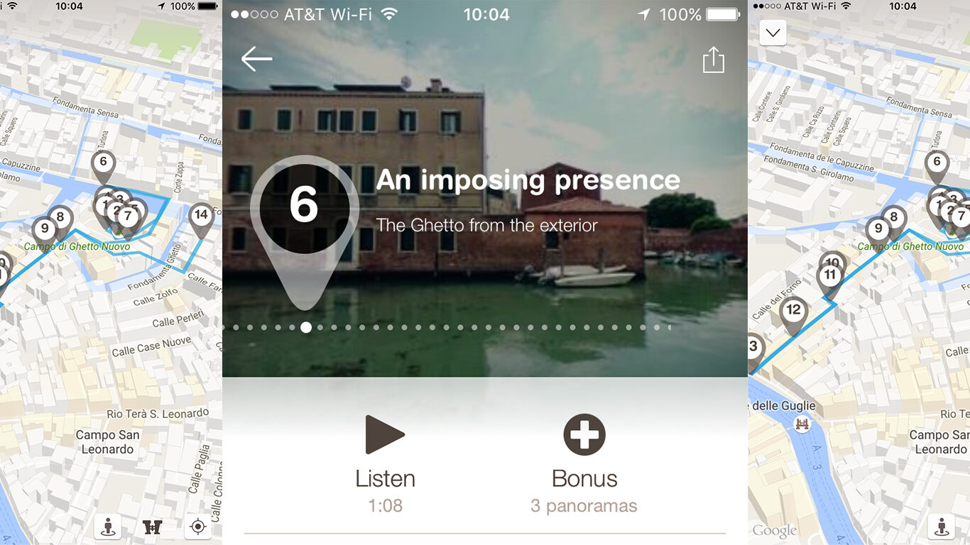
The Ghett/App mobile application was developed by Paolo Borin, Ludovica Galeazzo and Victoria Szabo of the Visualizing Venice team to complement the physical exhibition “Venice, the Jews and Europe 1516-2016,” which was held at the Palazzo Ducale in Venice from June 19 until November 13, 2016. Ghett/App is a augmented reality multimedia app designed to be used on-site in the Venetian Ghetto.
It highlights fourteen geolocated points of interest, drawing attention to the built features of the space as they have changed over time, through text, audio, image, video, and augmented reality experiences. While some of the app content was adapted from the museum exhibition as a way to situate the user, the augmented reality features were designed especially for use on location, and to take advantage of being in the actual space under discussion.
The team layered schematic 3D models of historic buildings with contemporary panorama images in order to demonstrate architectural change over time within the once-enclosed area of the Ghetto. Users can use the phone ‘s motion features to explore the panorama scenes dynamically. The ghostly edifices of the past rise up through the phone display, highlighting the changing nature of experience in the space. The AR features complement text and audio commentaries in English and Italian that explain the significance of particular structures, as well as the overall history of the area. While this version of the project was rolled out in conjunction with the exhibition opening, the team plans to continue developing content out of historical research materials, and integrating it into app channels. They hope to include some new materials developed by students in the Visualizing Venice Summer Workshop, as well as to explore other innovative ways to present content through image recognition and other advanced AR techniques. Szabo plans to include AR storytelling about Venice as a unit in her Digital Storytelling class at Venice International University this Fall as well.
Duke has established a close relationship with members of the Jacobs University community in Bremen, Germany. In 2012-13 several Jacobs graduate students came to campus as exchange students. We taught our Digital Cities course, which was coupled virtually with a course at Jacobs. Both courses met at the same time and videoconferences discussion and workshop sessions with one another, as well as sharing project crits.
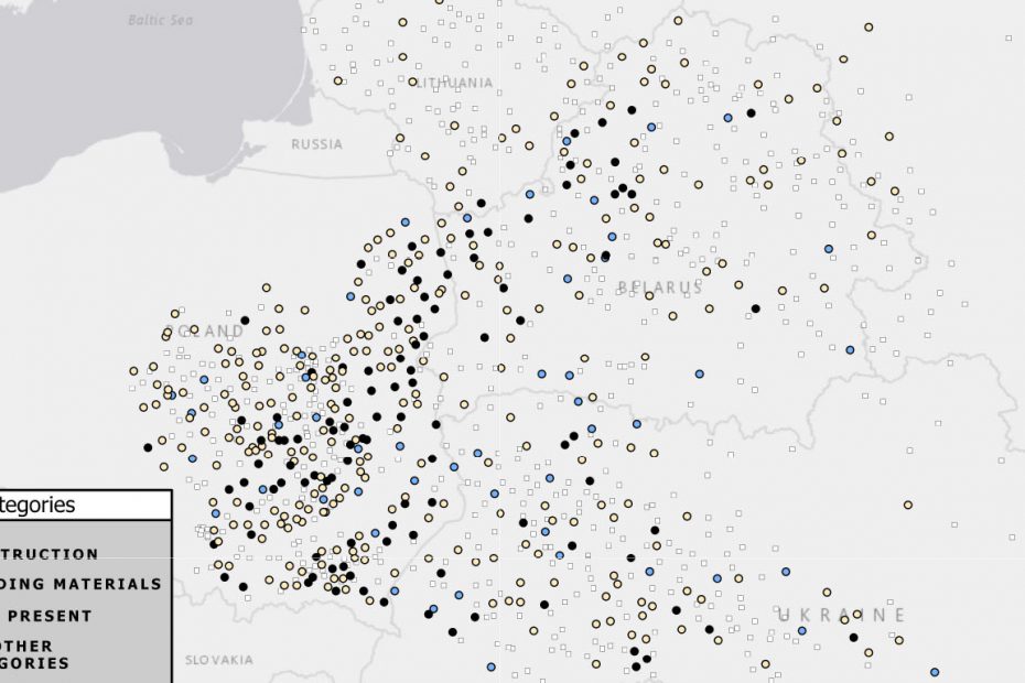
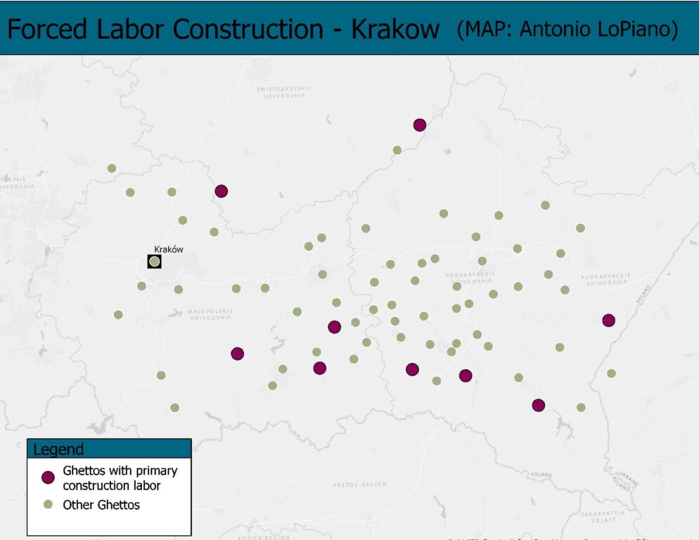
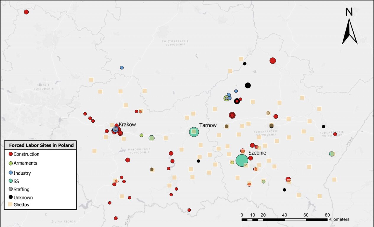
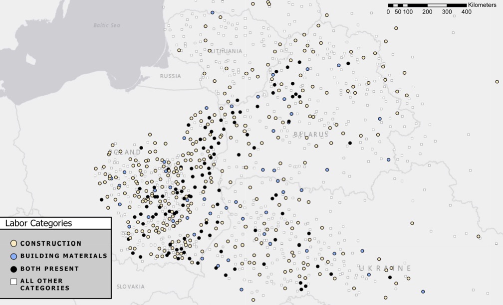
Few eras in Art History are as famous for their buildings as Weimar Germany (1918-1933) and none is more notorious than the Nazi period (1933-1945). Yet how are they related in terms of architects and architecture? This project seeks to probe the continuities and ruptures of cultural production between the two periods by looking at the German construction industry. This history from below (as it were) involves Art History in questions of labor, resource allocation, and the larger political economy of the state, among other issues. As such, the aim of the project is to gather and visualize large datasets of building campaigns throughout Germany to reveal patterns of construction that may raise other art historical problems. Special attention will be given to visualizing construction during World War II, such as in occupied Krakow, where construction, forced labor, and occupation policy came together. Overall, the project argues that making the invisible presence of construction visible in Art History through digital means helps us to expand and critique the canon of what has generally been considered “modern architecture.” At the same time, it will make the relationship of architecture and politics in modern society clearer.
Project sites of the Dyckerhoff & Widmann architecture firm, 1914-1930.
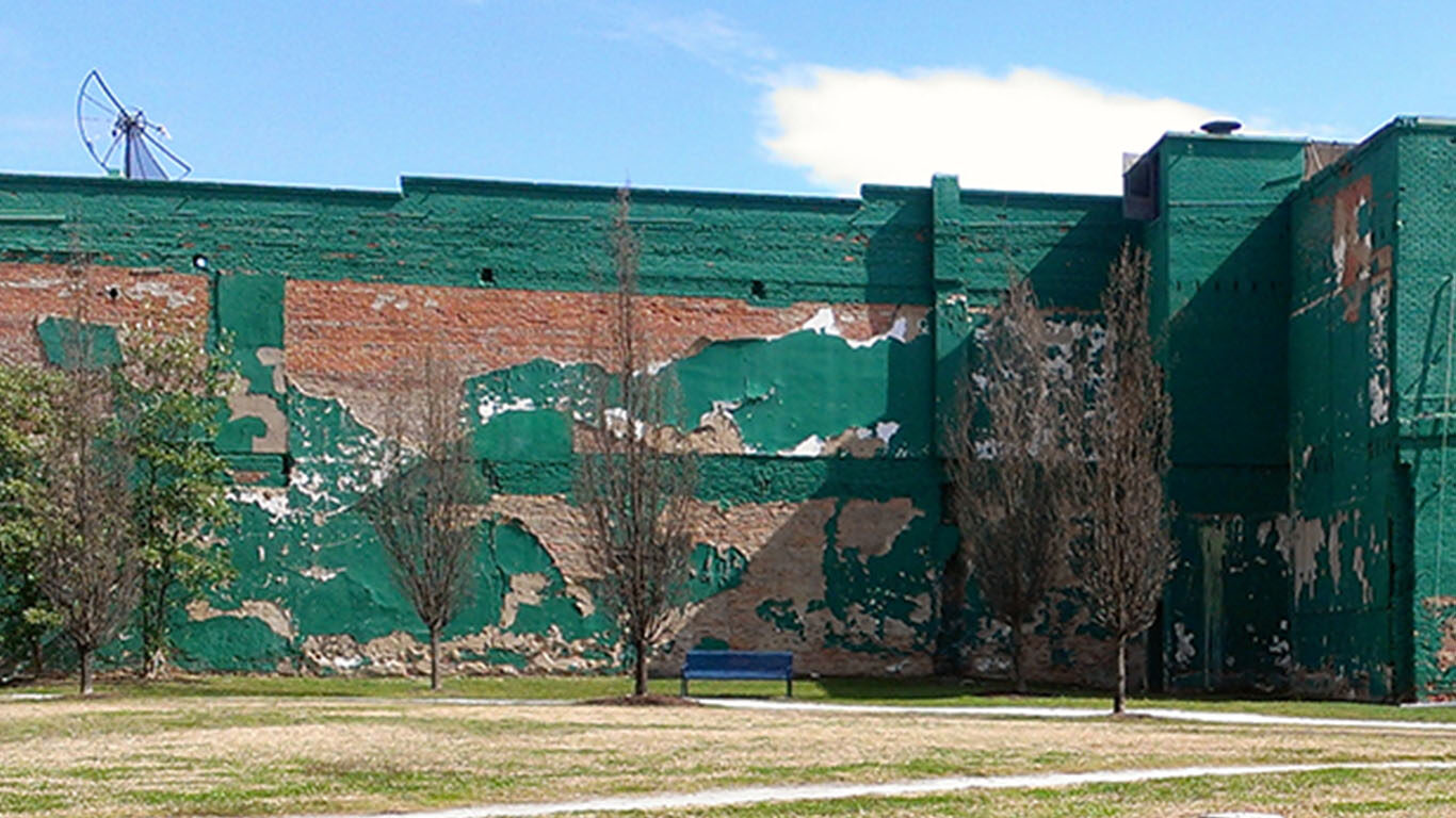
Forced labor construction in the Krakow region. Image Credit: Antonio LoPiano
Jaskot, Paul B. and Anne Kelly Knowles. “Architecture and Maps, Databases and Archives: An Approach to Institutional History and the Built Environment in Nazi Germany.” The Iris. February 15, 2017.
Jaskot, Paul B. and Ivo van der Graaff. “Historical Journals as Digital Sources: Mapping Architecture in Germany, 1914-24.” Journal of the Society of Architectural Historians 76, no. 4 (December 2017): 483-505. doi:/10.1525/jsah.2017.76.4.483.
Presentations
Jaskot, Paul B. “Scale and Ambiguity in the Digital Analysis of the Spaces of the Holocaust (or Why Bother Making an Art Historian a Member of Your Team).” Paper presented at the Research Computing Symposium, Duke University, Durham, NC, January 22, 2018.
Jaskot, Paul B. “A Plan, a Testimony, and a Digital Map: Analyzing the Architecture of the Holocaust.” Anne Tanenbaum Centre for Jewish Studies, University of Toronto, Canada, March 12, 2018.
Jaskot, Paul B. “The Scale of Architecture During the Holocaust: Digital Methods for Analyzing Building and Planning Goals in the German Occupation of the East (1939-1945).” Keynote for Digital Humanities und das NS-Regime (Conference), University of Bern, Switzerland, December 12, 2019.
Jaskot, Paul B. “Using Digital Humanities to Understand the Architecture of the Holocaust.” Paper presented at the Digital Art History Lab Lecture Series, The Frick Collection, New York, NY, October 17, 2017.
Jaskot, Paul B. “Visualizing Krakow under Nazi Occupation: Exploring Digital and Analog Methods to Analyze the Built Environment of the Holocaust.” Emory University, Atlanta, March 28, 2019.
Jaskot, Paul B., Anne Kelly Knowles, and Justus Hillebrand. “GIS and Corpus Linguistics: Mixed Digital Methods for the Exploration of Forced Labor in Krakow District Ghettos.” Paper presented at Digital Approaches to Genocide Studies, USC Shoah Foundation, Los Angeles, CA, October 23, 2017.
Jaskot, Paul B.”Visualizing Krakow under Nazi Occupation.” Society of Fellows in the Humanities, Columbia University, New York City, February 7, 2019.
Funding & Sponsorship
National Endowment for the Humanities, Level III, Digital Humanities Advancement Grant (2018-2022)
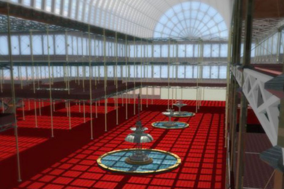
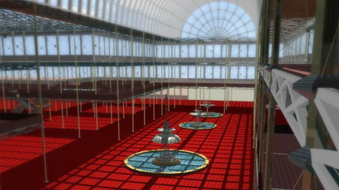
This project seeks to consider the Great Exhibition of 1851 as a place constructed in a highly determined space located in the physical and metaphorical heart of British colonial power. Famous both for the building itself, Paxton ‘s Crystal Palace, and the diverse objects and people from around the world that it contained, the Exhibition is nonetheless difficult to study as a spatial phenomenon due to its sheer complexity and scope. The diverse array of artworks, artifacts, machines, inventions, craft objects and human tableaux that were shown are richly documented in planning documents, photos, paintings, catalogs, engravings, new stories, travel narratives, and imaginative literature; the building itself is a favorite of architectural historians and engineers, who have reconstructed it in 3D numerous times.
This project attempts to brings together those approaches through an annotated virtual reconstruction of the Crystal Palace, to be populated by both the objects it contained, and the “users” who traversed it, in order to ask questions about the rhetoric of the place itself as a site of cultural self-representation and experience. Because no one technology adequately addresses this goal, our approaches brings together GIS and Google Earth assisted thematic maps and views of the content, contributor networks, and visitors to the Exhibition, as well as populated 3D immersive models to be experienced through the DiVE, virtual worlds and game environments. Underlying all of these will be a common database substrate of annotation and documentation, ideally accessible from any “view” – whether a website, 3D model, map, or immersive game-space.
Banner Image: Screenshot from the virtual Crystal Palace experience.
Past Collaborators
The Visualization Technology Group
The Virtual Realities FOCUS Cluster
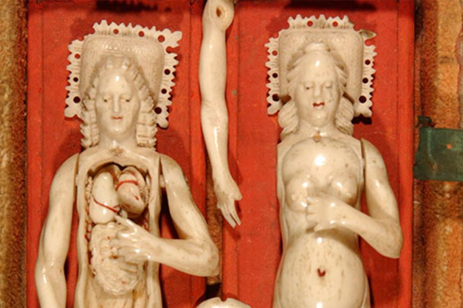
The Operating Archives project emerges out of a concern with the preservation of the “performativity” of objects in the digital archive. While digital archives afford access to historical texts, images, and objects to be read and viewed, often in a reconstituted contextual milieu, what about objects that were intended to be operated or manipulated? Taking the creation of a multimedia/multimodal archive of historical medical technologies as both case study and laboratory, this project explores different interfaces for interacting with digital objects that attempt to reconstruct contexts of use.
In conjunction with Duke’s History of Medicine Collection, one key focus of the project has been the processing, visualization, and 3D printing of Duke’s collection of ivory anatomical manikins, the largest collection in North America. Dating from the seventeenth and eighteenth centuries, the project aims to transform microCT scan data of each object into an interactive 3D model that can be manipulated virtually as well as displayed using augmented reality. 3D prints of the manikins also enable physical manipulation of artifacts otherwise too fragile to touch.
Banner Image: Two ivory manikins from the Rubenstein Library’s History of Medicine collection. Image credit: Mark J. V. Olson
Past Collaborators
Catherine Farmer
Stephanie Fiddy
Alex Gordon
Yuchen “Leona” Lu
Jason Qiu